
Moderate magnitude 5.3 earthquake at 33 km depth

8 Dec 23:47 UTC: First to report: GEONET (NZ) after 14 minutes.
8 Dec 23:50: Magnitude recalculated from 5.4 to 5.5. Hypocenter depth recalculated from 0.0 to 33.0 km (from 0 to 21 mi). Epicenter location corrected by 20 km (12 mi) towards NE.
9 Dec 00:02: Magnitude recalculated from 5.5 to 5.2. Epicenter location corrected by 8.3 km (5.2 mi) towards ESE.
9 Dec 00:20: Magnitude recalculated from 5.2 to 5.3. Epicenter location corrected by 7 km (4.3 mi) towards WNW.
I felt this quake
I didn’t feel it
Date & time: 8 Dec 2020 11:33:29 UTC –
Local time at epicenter: Tuesday, 8 Dec 11.33 am (GMT -12)
Magnitude: 5.3
Depth: 33.0 km
Epicenter latitude / longitude: 28.58815°S / 175.6161°W ![]() (South Pacific Ocean, New Zealand)
(South Pacific Ocean, New Zealand)
Nearest volcano: Raoul Island (236 km / 147 mi)
Nearby towns and cities:
810 km (503 mi) S of ‘Ohonua (Ohonua, Tonga) (pop: 1,240) See nearby quakes!
830 km (515 mi) S of Nuku’alofa (Tonga) (pop: 22,400) [quakes]831 km (516 mi) S of Kolonga (Tonga) (pop: 1,100) [quakes]
Broken Clouds
 21.6°C (71 F), humidity: 75%, wind: 6 m/s (11 kts) from ENE
Primary data source: GEONET (NZ)
Estimated released energy: 5.6 x 10¹² joules (1.56 gigawatt hours, equivalent to 1344 tons of TNT) More info

Also if you did NOT feel the quake although you were in the area, please report it! Your contribution is valuable also to earthquake science and earthquake hazard analysis and mitigation efforts. You can use your device location or the map to indicate where you were during the earthquake. Thank you!
Data for the same earthquake reported by different agencies
Info: The more agencies report about the same quake and post similar data, the more confidence you can have in the data. It takes normally up to a few hours until earthquake parameters are calculated with near-optimum precision.
| Magnitude | Depth | Location | Source |
| M 5.3 | 33 km | New Zealand | GEONET (NZ) |
| M 5.7 | 60 km | KERMADEC ISLANDS REGION, New Zealand | EMSC |
| M 5.3 | 10 km | Kermadec Islands Region, New Zealand | USGS |
| M 5.7 | 58 km | Kermadec Islands Region, New Zealand | GeoAu |
User reports for this quake
Contribute:
Leave a comment if you find a particular report interesting or want to add to it.
Flag as inappropriate.
Mark as helpful or interesting.
Send your own user report!
There are no user reports for this quake yet. If you felt it be the first to report it!
Try our free app!
Aftershocks of the 5.3 quake South Pacific Ocean, 830 km south of Nuku’alofa, Tongatapu, Tonga, New Zealand, 8 Dec 11.33 am (GMT -12)
More info
Recorded aftershocks, latest first (0 quakes so far, frequently updated):
So far, no aftershocks have been registered.
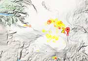
Earlier earthquakes in the same area since 1900
Moderate mag. 5.3 earthquake – South Pacific Ocean, 830 km south of Nuku’alofa, Tongatapu, Tonga, New Zealand, on Tuesday, 8 Dec 11.33 am (GMT -12)
Map of earlier quakes
Try our free app!
More on VolcanoDiscovery


“Esploratore. Appassionato di bacon. Social mediaholic. Introverso. Gamer. Studente esasperatamente umile.”